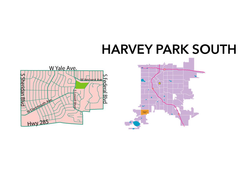
Neighborhood Profile: Harvey Park South
Harvey Park South History:
Forty-five acres of the Harvey Park South area were first purchased in 1890 for the St. Mary’s Academy. The Catholic girls’ school was run by the Sisters of Loretto and had outgrown its previous location. The school was a five-story, 186 room, Romanesque-style Building. The Sisters almost lost the property in the silver crash of 1893. Mother Praxedes Carty persuaded the mortgage holders to extend the loan, and the school was not only saved but prospered in the coming decades.
Fair Hill farms were the other prominent property in the region. West of St. Mary’s, owner John Flower planted lush gardens, built multiple barns, and had an orchard with many fruit trees. He sold the property to a U.S. Navy Commander who, in-turn, sold it to Herbert C. Stebbins in 1942. Stebbins and his daughter restored the run-down property and named the land Hillcroft. For ten years they ran a small farm and raised varying small livestock. During this time the Catholic school became Loretto Heights College, a four-year women’s college. Herbert Stebbins made a deal with Loretto Heights College to sell the property to them upon his death.
A majority of the neighborhood was untouched until the mid-twentieth century. In 1958 the land was annexed to Denver. During this time the city saw a large increase in population as GI’s were returning from war. The first development platted during this time was Sharon Park. Soon new subdivisions were popping up to the west of the college. Because the neighborhood of Harvey Park to the north was almost fully developed this new area was commonly referred to as Harvey Park South.
By 1960 the neighborhood seemed mostly built-out, yet numerous parcels both large and small remained vacant. Today, high-density apartments have been built on some of those parcels. Others, totaling about 100 acres, remain undeveloped.
Harvey Park South Today:
Harvey Park South is a quiet neighborhood with a suburban feel. A majority of the homes are mid-century brick, ranch-style homes. The community is home to mostly long-time residents and families.
Where:
Harvey Park is bounded by W. Yale Avenue to the north, U.S. Highway 285 to the south, S. Sheridan Boulevard to the west and S. Federal Boulevard to the east.
Who Lives There:
The population is 45% married, 32% single and 29% of households have children. The Annual Residential Turnover is 18.29%.
Retail Areas:
Sheridan Blvd.
Hampden Ave.
Federal Blvd.
Median Sales Price:
$342,500 for a single-family residence (2017)
Main Attractions:
Strong community involvement and outreach
Common Complaints:
Grafitti and tagging on buildings
Schools:
Sabin Elementary School
DSST: College View Middle School and High School
Colorado Heights University
Gust Elementary School
Local Parks:
Loretto Heights Park
Public Transportation and Bike Lanes:
Buses servicing neighborhood: 27 (W. Yale Ave./ Raleigh St./ Federal Blvd.), 30, 30C (Lowell Blvd.), 50, 51 (Sheridan Blvd.) and 29, 36, 36L (Federal Blvd.)
Shared lane bicycle routes: D20 (W. Yale Ave.), D1 (S. Raleigh St.), D3 and D22-A (S. Lowell Blvd./ Knox Ct.) and W. Bates Ave. D22 is a bike lane running W. Dartmouth Ave.
Art Venues and Annual Events:
Harvey Park Improvement Association: http://www.harveypark.org
Sharon R. Catlett.
Farmlands, Forts & Country Life: The Story of Southwest Denver
Published by Big Earth Publishing, Boulder, CO.
2007. Print.
“Harvey Park South”
Community Facts: Neighborhood Summaries
http://denvermetrodata.org/neighborhood/harvey-park-south
Copyright 1998, The Piton Foundation. Web.8/2017.
Statistical data collected from Metrolist, Inc. RE Colorado – powered by Matrix.