 Neighborhood Profile: Central Park
Central Park History:
Central Park, (formerly Stapleton) located seven miles outside of downtown Denver, was originally known as Sand Creek or Rattlesnake Hollow. In the early 1920s, the aviation industry was steadily growing in Denver. Mayor Benjamin Stapleton wanted to build a local airport to centralize this growth. The mayor secured Charles Vail, the manager of the Improvements and Parks Department, to help oversee the development. Ultimately the pair chose Rattlesnake Hollow as the best location.
The airport met with resistance from locals right from the start. Many Denver residents were worried about the costs of such a huge commercial venture. Even with the opposition, the airport opened in October 1929 and was named Denver Municipal Airport (DMA.) In its first year, DMA turned a profit and over the next decade, it would steadily grow.
After World War II the number of people flying commercially grew exponentially. DMA grew as well and in 1944 was renamed Stapleton Airfield in honor of the current mayor. Over the next several decades the airport would continue to expand. The original 640 acres of land increased to over 4,00o acres. By 1961 Stapleton was ranked third in the country for total aircraft operations. Soon, the airport was renamed, again, as Stapleton International Airport.
In the 1980’s Stapleton International Airport was outgrowing its location. With an increased demand for national and international air traffic and the size of new aircraft, the airport needed more land to expand. A new airport was built further east and Stapleton International Airport closed in February of 1995. Six years later the city began redevelopment of the land for new housing with a mixed-development community.
Today:
Denver’s continuous growth has made the redevelopment of Central Park essential. Three thousand acres are being developed with 4,000 apartments, 8,000 houses and 2 million square feet of retail space. Over 1,000 acres are designated for parks and open space. When all construction is complete in 2020, Stapleton will house up to 30,000 people.
Where:
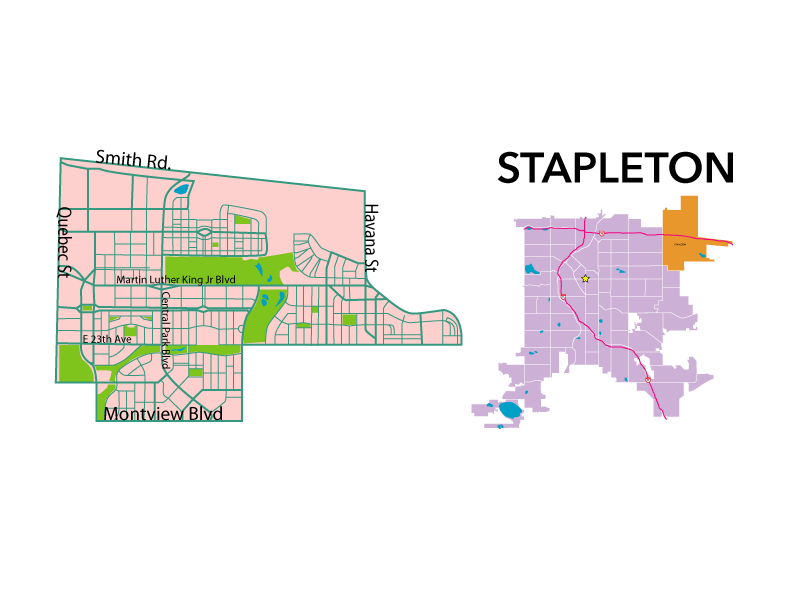
Central Park is bounded by E. 56th Ave./ Wildlife Drive to the north, Montview Boulevard/ E. 26th Ave. to the south, Quebec Street to the west and Havana St./ Lima St. to the east.
Who Lives There:
The population is 52% married, 32% single and 53% of households have children. The Annual Residential Turnover is 26.58%
Retail Areas:
Quebec Street
36th Avenue
29th Avenue
Syracuse Street
Yosemite Street
Northfield Blvd.
Median Sales Price:
$538,450 (2017): $382,500 for a condo/ townhouse, $630,775 for a single family residence.
Main Attractions:
There are close to 50 parks in the neighborhood, three public swimming pools and great mass transit, including the RTD light rail.
Common Complaints:
Heavy traffic through the center of the neighborhood. Central Park Boulevard is a straight shot from the new I-70 exit down to Montview.
Schools:
William Roberts Elementary School, Isabella Bird Community School, Swigert International School, Denver School of Science & Technology, Montessori Children’s House of Denver, Westerly Creek Elementary School, Primrose School at Stapleton, Creative Learning Preschool- Denver, Northfield High School, The Goddard School, High Tech Elementary School and Denver Discovery School
Local Parks:
Westerly Creek Park, Puddle Jumper Park, Arc Park, Bouquet Park, Cherry Pie Park, Rumble Park, Sharp Park, Central Park and rec center, Winter Park, Autumn Park, Summer Park, Spring Park, Arrowhead Park, Yosak Pocket Park, Fred Thomas Park, Founder Green, GreenWay Park, Sharpetz Park, Stapleton Off-Leash Park, Constellation Park, Rolling Bluff Park, Pea Pod Park, Cottonwood Clearing Park, Lifted Meadow Park, Willow Basin Park, Willow Park East Dog Park, Harvest Park, Conservatory Green, Pocket Park, Northfield Pond Park, The Green (North), Bluff Lake Nature Center, Runway 35 Park, Quilted Park, Sand Creek Regional Greenway, Smith Road Trailhead, *Aviator Park and Pool, *F-15 Pool in Stapleton and *Jet Stream Pool
Public Transportation and Bike Lanes:
The RTD A light rail stops at Central Park Station.
Busses servicing the neighborhood (including service from Central Park Station): 28, 34, 37, 42, 43, 62, 65, 73, 88, 89 and 105
Bike Lanes in the neighborhood include: D2 (Smith Rd. & E. 47th Ave.), D21 (Central Park Blvd.), D8 (Montview Blvd.), D19 (Syracuse St.), D6 (E. 29th Ave.), D6-A ( E. 26th Ave. through Greenway Belt Park) and Havana Street
Multi-use trails: Sand Creek Greenway Trail, Westerly Creek Trail, Northfield Pond Park and two in Central Park
Resources for Annual Events:
Stapleton Master Community Association: http://www.stapletoncommunity.com
“Our Story”
Stapleton Denver: Community
http://history.denverlibrary.org/capitol-hill-neighborhood-history
Web.6/2017
“Stapleton International Airport”
Stapleton International Airport: Articles
https://coloradoencyclopedia.org/article/stapleton-international-airport
Copyright 2016, Colorado Encyclopedia. Web.6/2017.
Statistical data collected from Metrolist, Inc. RE Colorado – powered by Matrix.


